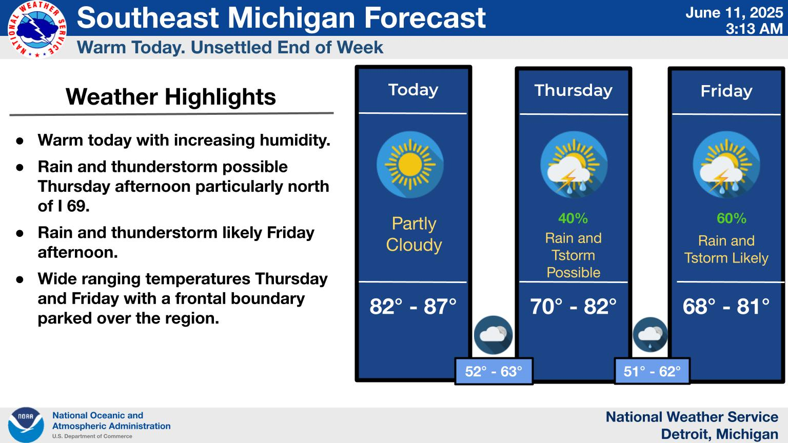
London
Weather Homepage | Blissfield | Breckenridge | Brown City | Jasper | Lansing | London | Marlette | Middleton | Newaygo | Tupperville

Blissfield
 
Breckenridge
  
Brown City
  
Jasper

Lansing
London
   
Marlette
Middleton
 
Newaygo
 
  
Tupperville
Breckenridge, MI. Climate Data
For Friday, February 5, 2010
Normal High: 28.0
Record:  52.0  In 1991

Normal Low : 10.0
Record: -14.0  In 1978

Precipitation
Record:  0.99 In 1986


2009-10 Season Snowfall: 21.1
7:00am Snow Depth: 3.5

2008-09 Snowfall: 70.4
2007-08 Snowfall: 66.8
2006-07 Snowfall: 25.2
2005-06 Snowfall: 38.1
2004-05 Snowfall: 62.7


Blissfield   Brown City  Breckenridge  Jasper  Lansing  Marlette  Middleton  Newaygo
 
London  Tupperville        mailto:msterling@michag.com
Mid-Michigan-Weather.Com Is Hosted By: ISP Management of Alma

MAC Breckenridge is part of the
Global Weather Network AWEKAS

&nb 

BY 6:00PM I EXPECT THE NWS WILL HAVE ALREADY POSTED A WINTER STORM WARNING FOR MOST IF NOT ALL OF THE MAC AREA .....   THE BEST CHANCE FOR THE HEAVIEST SNOWS OF 10 TO 12 INCHES STILL LOOKS TO BE IN THE AREA FROM JACKSON TO GRAND RAPIDS TO LANSING...... SOUTH OF MT PLEASANT 7 TO 10 INCHES LOOKS VERY POSSIBLE AND ALL AREAS WILL THEN SEE CONSIDERABLE BLOWING AND DRIFTING SNOW LATER TUESDAY EVENING INTO WEDNESDAY NIIGHT............

Slideshow 

image


Since your web browser does not support JavaScript, here is a non-JavaScript version of the image slideshow:

slideshow 

image


slideshow image


slideshow image


slideshow 

image


slideshow image


slideshow 

image


slideshow 

image


slideshow 

image


slideshow 

image


ISP Management


Monday, February 8,  2010  10:30am : 2009 GROWING SEASON  MAC-LAC  WEBCAMS
Winter Storm Tuesday - Wednesday 6 to 12 Inches, Blowing & Drifting Snow !

Models continue to paint a widespread area of 8 to 12 inch snowfall for all of the MAC area, to the right is the local computer forecasted snowfall amounts for cities in the MAC area and not much has changed since the 3:00am forecast. Winds on the models look a bit stronger for Tuesday Night and Wednesday so considerable blowing and drifting will be a big factor. I expect many schools will be closed on Wednesday and with winds blowing good through at least Wednesday evening Thursday could also see some or many school closings, but will look at that tomorrow as the storm hits and we have a better idea of how long the strong winds will continue, with local Government budgets as they are most road crews are trying to run mainly during the day on secondary and rural roads if possible or so I would assume.    
Have A Nice Day !


./a>
Rainfall Outlook

 
il
 

RADAR   -   JET STREAM   -   MICHIGAN FORECAST   -   6-10 DAY   -   8-14 DAY   -   30 DAY   -   90 DAY    MESOSCALE  -  2008 GDD   -   USDA WEATHER   -   SCHOOL CLOSINGS   -   DATABASE   -   STATION RAINFALL 
PAST STORMS   - 
 STATE RADAR   -   NATIONAL RADAR   -   CURRENT MAP   -   BRECKENRIDGE CLIMATE
30 DAY RAINFALL  .   BILL's BLOG (WOOD TV 8)  -  OTHER LINKS  - 
Watch Map  -  Printable Outlook
Local Computer Snow Forecast
Storm Totals Projected
MAC Location Forecast
Newaygo 8.9
Mt Pleasant 8.7
Breckenridge 10.1
Middleton 11.8
Lansing 12.3
Marlette 9.3
Brown City 9.4
Blissfield 8.7
Jasper 9.0
Updated: 10:30am Monday